Poetry Along the Columbia River Gorge
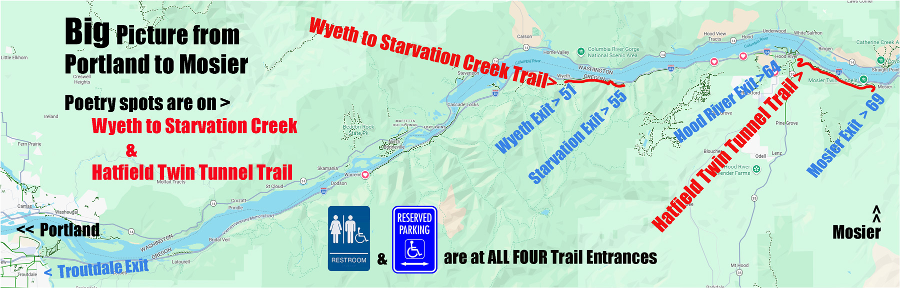
Map Directions to Poems and Artwork

Self Directed Pop Up Event only on April 11 & April 12th (Saturday & Sunday)
Maps and Directions to Poetry and Artwork
Rest Room locations & Detailed I-84 Exits below
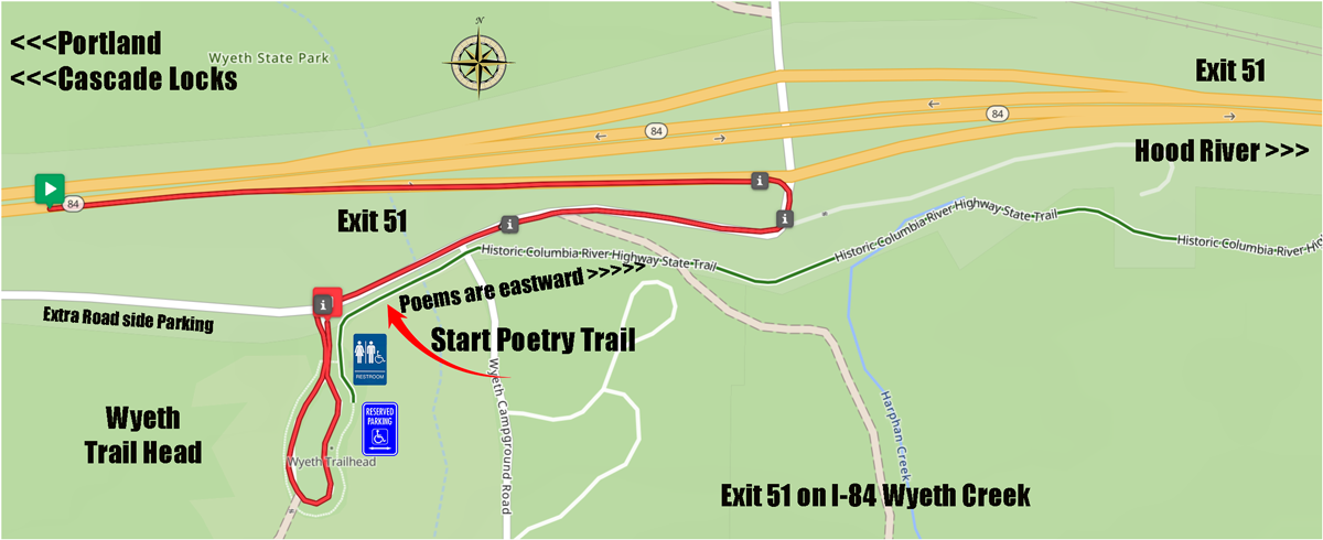
Two Poets are on Wyeth to Starvation Creek trail.
One Poet is on the Hatfield Twin Tunnel trail.
One visual Artist is on the Hatfield Twin Tunnel trail.
Poems by Claudia Castro Luna & Kelly Lenox
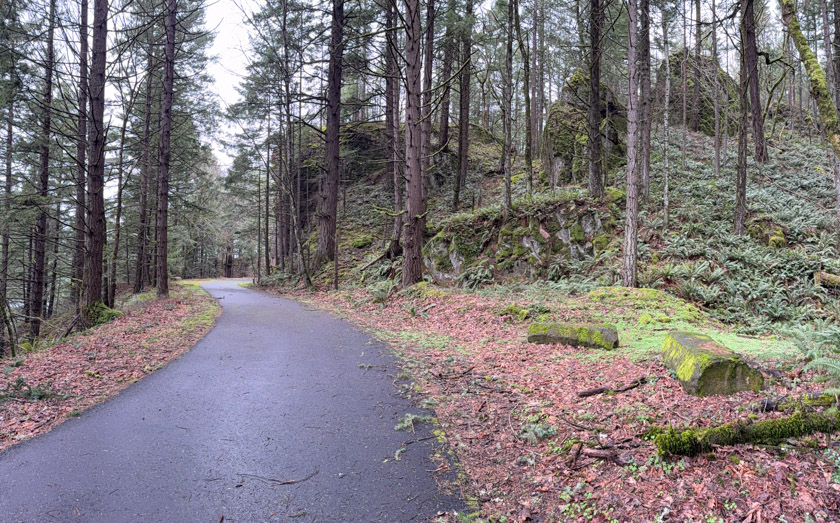
Section 1: Wyeth to Starvation Creek Trail on the Car Free paved trail
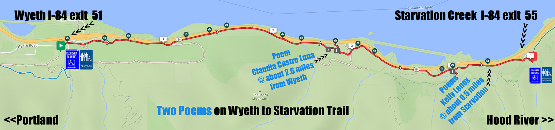
Poem of Claudia Castro Luna
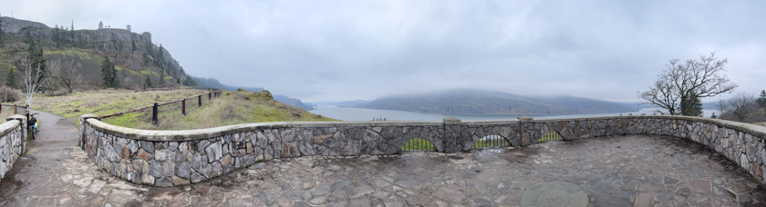
Poem is under lush forest canopy leading to an overlook of the Columbia River and Wind Mountain.
Poem Starts Poem reads from West to East from Wyeth
Western Exit: Wyeth I-84 exit 51
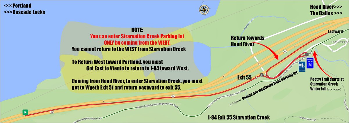
Eastern Exit: Starvation I-84 exit 55 Beware exit 55 has no westard to Portland Return I-84 entrance. You must continue Eastward to the Viento exit I-84 exit 56 in order to return west to Portland direction.
Distance to Poem: Poems begins about 2.5 miles from western Wyeth Parking lot or about 2+ miles from eastern Mosier parking lot.
Notes: This route is fun to cycle-roll-walk as it tucks into the forest canopy and then on to viaducts overlooking the Columbia and Washington. Wind Mountain is your constant companion sentinel. After you arrive at Starvation Rock, you continue another two miles which has the sentinel of Mitchell Pt in the eastern turn of the River. The trail section to Mitchell is incomplete. Expectation of completion is by Autumn 2026.
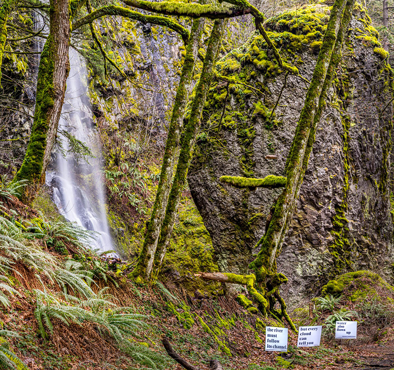
Poems of Kelly Lenox
Two Poems are intertwined with two intimate water falls. In the winter, there have been pika and mink along these falls.
Poem Starts Poem reads from East to West from Starvation
Eastern Exit: Starvation I-84 exit 55 Beware> exit 55 has no westward to Portland Return I-84 entrance. You must continue Eastward to the Viento I-84 exit 56 in order to return west to Portland direction.
Distance to Poem: Poems begins about 0.5 miles from Starvation parking lot or about 4.5 miles from western Wyeth parking lot.
Notes: This route is near the Starvation Creek parking lot. At the parking lot> you can head 50 yards east (or left) and see Starvation Creek on a paved path; you can head west (or right) to see Cabin Falls and Hole in the Wall Falls.
Poem by Kara Brigg & Artwork by Speakthunder Berry
Section 2: Hatfield Twin Tunnel Trail on the Car Free paved trail
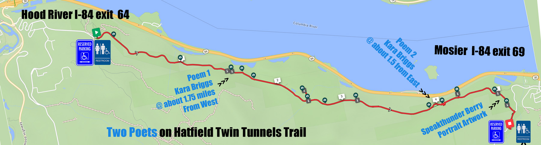
Poems of Kara Briggs
Two Poems are views seeing east and west of the mighty Columbia River Gorge scoured by the repeated Missoula Floods 15 to 30,000 years ago.
Western Poem 1 Starts: about 1.75 miles from the Hatfield West parking lot.
Eastern Poem 2 Starts: about 1.5 miles from the Mosier-Hatfield East parking lot.
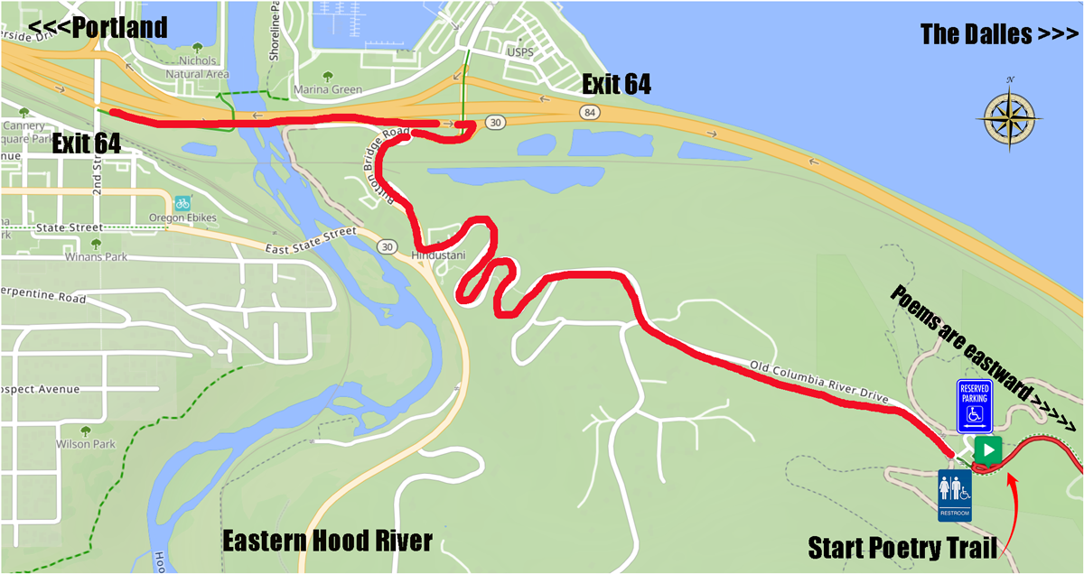
Western Exit: Hood River I-84 64
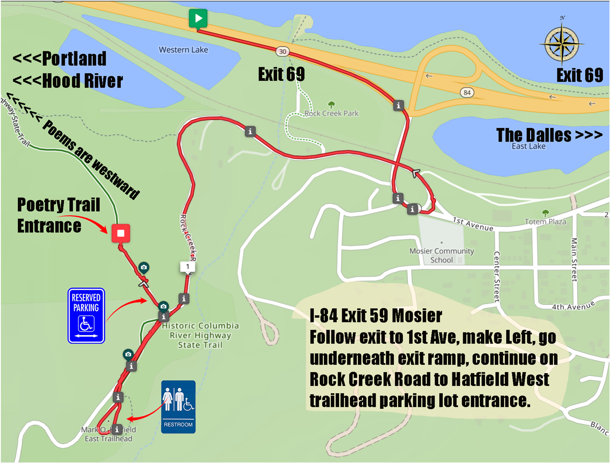
Eastern Exit: Hood River I-84 69
Distance to Poem: Poem 1 begins about 1.75 miles from Hatfield West parking lot and Poem 2 is about 1.5 miles from Hatfield East parking lot.
Notes: This route welcomes the transition from Forest to the High Desert. The flowers that appear much of the year are unique and require different needs from high western drainage & rainfall to the lower easter water fall along the Columbia.

Artwork of Speakthunder Berry
Western Artwork spans about 0.5 miles from the Mosier- Hatfield eastern parking to the eastern Twin Tunnels exit.
Eastern Exit: Mosier 69
Westrern Exit: Hood River I-84 69
Distance to Artwork: Images begin about 0.5 miles from Mosier parking lot and continues west to the Eastern entrance of the Twin Tunnels another 0.50 miles.
Notes: This route shows the dry eastern high desert penumbra. The large scree rains small rock from the 250 ft peak above the trail. This rock slide looks forbidding but is a step away from producing prolific native flowers including balsam root, lupine, fiddleneck and camas.
Rest Rooms locations Below

Wyeth State Park at the western trail head has two accessible restrooms
Starvation Exit Parking Lot has two accessible restrooms
Hatfield Western Trailhead parking lot has two accessible restrooms
Hatfield Eastern Trailhead parking lot has two accessible restrooms
Wyeth Creek Exit
Poetry trail Begins and Goes East to Starvation Creek Falls
Starvation Falls Exit
Poetry trail Begins and Goes West to Wyeth Trailhead
Hood River Exit To Western Mark O Hatfield trailhead
Poetry trail Begins and Goes East to Hatfield Western trailhead at Mosier
Hood River Exit To Eastern Mark O Hatfield trailhead
Poetry trail Begins and Goes West to Hatfield Eastern trailhead at Hood River
the Earth Abides
Copyright © 2026 · All Rights Reserved · GorgePedal.com